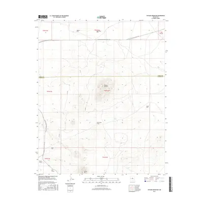
2017 Map of Veteado Mountain
USGS Topo · Published 2017About this map
Veteado Mountain dominates this high-altitude landscape along the border of Cibola and Catron counties. This 2017 survey documents a region defined by its complex drainage network and varied topography, where the Continental Divide National Scenic Trail winds through the western reaches of the quadrangle. The terrain is marked by significant elevation changes, with Techado Mtn rising in the south near Wyche Canyon and Pine Canyon. Water sources are sparse but critical, evidenced by named features like Dutch Lake, Spring Ten, and the intermittent Deep Water Draw. A network of unpaved roads, including Co RD a046 and Co RD a047, provides the primary access across these canyons and draws, reflecting the quiet, rural character of this part of New Mexico. The map provides a detailed view of the natural landmarks and remote passages used by hikers and local ranchers alike.
Find a feature on this map
22 named features on this map. Tap any name to fly to it.
Don’t see what you’re looking for? This feature index may not catch every label — zoom into the map to look around manually.
Map Details
Editions of this 2017 Veteado Mountain Map
This is the sole edition of this map. No revisions or reprints were ever made.
Other maps of this area

1954 · Saint Johns
USGS Topo · 1:250,000

1957 · Saint Johns
USGS Topo · 1:250,000

1958 · Saint Johns
USGS Topo · 1:250,000

1962 · Saint Johns
USGS Topo · 1:250,000

1967 · Mariano Springs
USGS Topo · 1:24,000

1967 · Chimney Hill
USGS Topo · 1:24,000

1967 · Adams Diggings
USGS Topo · 1:24,000

1967 · Blue Hills
USGS Topo · 1:24,000

1967 · Veteado Mountain
USGS Topo · 1:24,000
1967 · Cerro Pomo
USGS Topo · 1:24,000