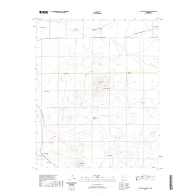
2020 Map of Veteado Mountain
USGS Topo · Published 2020About this map
Continental Divide National Scenic Trail winds through the high desert of west-central New Mexico, crossing the boundary between Cibola and Catron counties. This arid landscape is defined by its dramatic volcanic and tectonic topography, anchored by the prominent heights of Veteado Mtn and Techado Mtn. The survey reveals a complex network of seasonal drainages and canyons, including the significant Horse Camp Canyon, Wyche Canyon, and Pine Canyon. Water sources are scarce and vital in this environment, indicated by localized features like Dutch Lake, Spring Ten, and the seasonal Deep Water Draw. The map illustrates a remote terrain where human passage is primarily defined by long-distance trails and historical ranching activity, as seen in the various named draws such as Techado Draw, Tingle Draw, and Keller Draw that carve through the high plateaus.
Find a feature on this map
21 named features on this map. Tap any name to fly to it.
Don’t see what you’re looking for? This feature index may not catch every label — zoom into the map to look around manually.
Map Details
Editions of this 2020 Veteado Mountain Map
This is the sole edition of this map. No revisions or reprints were ever made.
Other maps of this area

1954 · Saint Johns
USGS Topo · 1:250,000

1957 · Saint Johns
USGS Topo · 1:250,000

1958 · Saint Johns
USGS Topo · 1:250,000

1962 · Saint Johns
USGS Topo · 1:250,000

1967 · Mariano Springs
USGS Topo · 1:24,000

1967 · Chimney Hill
USGS Topo · 1:24,000

1967 · Adams Diggings
USGS Topo · 1:24,000

1967 · Blue Hills
USGS Topo · 1:24,000

1967 · Veteado Mountain
USGS Topo · 1:24,000
1967 · Cerro Pomo
USGS Topo · 1:24,000