1960 Map of Veteran
USGS Topo · Published 1993About this map
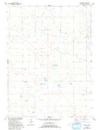
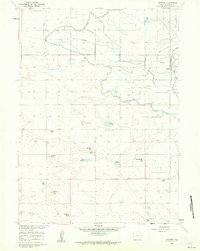
Agricultural development in the Goshen Hole region is defined by the extensive irrigation network shown here, anchored by the Fort Laramie Canal. The settlement of Veteran serves as a small hub for the surrounding ranching country, where family-named operations like Carlson Ranch, Yerges Ranch, and Day Ranch are scattered across the plains. This landscape reflects the Bureau of Reclamation's influence on the High Plains, where water management features like the Cherry Creek Drain and Halter Drain transformed the arid terrain.
Find a feature on this map
21 named features on this map. Tap any name to fly to it.
Don’t see what you’re looking for? This feature index may not catch every label — zoom into the map to look around manually.
Map Details
Editions of this 1960 Veteran Map
2 editions found
Other maps of this area

1896 · Patrick
USGS Topo · 1:125,000

1896 · Hartville
USGS Topo · 1:125,000

1899 · Goshen Hole
USGS Topo · 1:125,000

1901 · Hartville
USGS Topo · 1:125,000
1950 · Rockeagle
USGS Topo · 1:24,000

1954 · Torrington
USGS Topo · 1:250,000

1954 · Cheyenne
USGS Topo · 1:250,000

1958 · Cheyenne
USGS Topo · 1:250,000

1958 · Torrington
USGS Topo · 1:250,000
1960 · Habig Spring
USGS Topo · 1:24,000