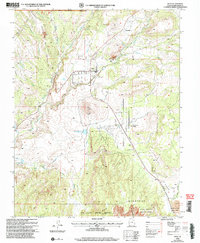
2002 Map of Veyo
USGS Topo · Published 2005About this map
Veyo and the surrounding high desert terrain are defined by a complex intersection of volcanic history and essential water management near the turn of the 21st century. The landscape is dominated by the prominent Veyo Volcano, with local industry evidenced by a Cinder Pit and a Power Plant along the Santa Clara River. This survey captures the residential growth of Dammeron Valley and the smaller settlement of Brookside, situated near the rugged boundaries of the Dixie National Forest. Critical infrastructure is mapped in detail, including an extensive Pipeline system and the Aquaduct that connects with the Upper Sand Cove Reservoir and Lower Sand Cove Reservoir. These water features, alongside drainages like Magotsu Creek and Cove Wash, illustrate the vital role of irrigation and storage in this arid environment, while conservation efforts are marked by the Red Cliffs Desert Reserve and Snow Canyon State Park.
Find a feature on this map
31 named features on this map. Tap any name to fly to it.
Don’t see what you’re looking for? This feature index may not catch every label — zoom into the map to look around manually.
Map Details
Editions of this 2002 Veyo Map
This is the sole edition of this map. No revisions or reprints were ever made.
Other maps of this area

1885 · St. George
USGS Topo · 1:250,000

1891 · St. George
USGS Topo · 1:250,000

1953 · Cedar City
USGS Topo · 1:250,000

1954 · Beaver Dam Mts NE
USGS Topo · 1:24,000

1954 · Gunlock
USGS Topo · 1:24,000

1954 · St. George
USGS Topo · 1:62,500

1956 · St. George NW
USGS Topo · 1:24,000

1956 · St. George NE
USGS Topo · 1:24,000

1958 · Cedar City
USGS Topo · 1:250,000

1962 · Cedar City
USGS Topo · 1:250,000