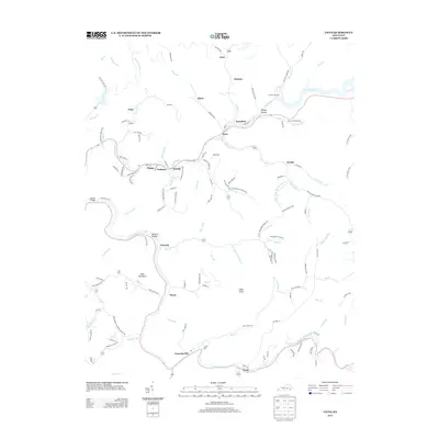
2013 Map of Vicco
USGS Topo · Published 2013About this map
Vicco and the surrounding mountain communities of Sassafras and Allock occupy the narrow valley floor where Carr Fork meets Montgomery Creek. This 2013 survey illustrates the dense string of settlements characteristic of the Kentucky coalfields, where homes and infrastructure are concentrated along the winding banks of the North Fork Kentucky River. Genealogists will find numerous family-centric landmarks throughout the terrain, including Cornett Hill Cemetery, Hall Cemetery, and Turner Cemetery. The landscape is further defined by its many hollows and forks, such as Rowdy Hollow, McIntire Hollow, and the Straight Fork. Small hamlets like Happy, Defiance, and Scuddy are connected by a network of local roads that follow the creek beds, providing a clear view of the regional development patterns at the start of the twenty-first century.
Find a feature on this map
139 named features on this map. Tap any name to fly to it.
Don’t see what you’re looking for? This feature index may not catch every label — zoom into the map to look around manually.
Map Details
Editions of this 2013 Vicco Map
This is the sole edition of this map. No revisions or reprints were ever made.
Other maps of this area

1890 · Whitesburg
USGS Topo · 1:125,000

1891 · Hazard
USGS Topo · 1:125,000

1892 · Whitesburg
USGS Topo · 1:125,000

1912 · Hindman
USGS Topo · 1:48,000

1913 · Oven Fork
USGS Topo · 1:48,000

1914 · Troublesome
USGS Topo · 1:62,500

1915 · Hindman
USGS Topo · 1:62,500

1915 · Whitesburg
USGS Topo · 1:62,500

1916 · Cornettsville
USGS Topo · 1:62,500
1954 · Hindman
USGS Topo · 1:24,000