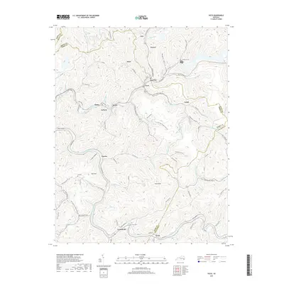
2019 Map of Vicco
USGS Topo · Published 2019About this map
Vicco and the surrounding mountain settlements of Perry, Knott, and Letcher counties are defined by the winding hollows of the Kentucky Appalachians. The landscape is a dense network of creek-side communities, including Wiscoal, Sassafras, and Cornettsville, where development follows the narrow valley floors of Carr Fork and its numerous tributaries. These settlements are often centered around the local geology and coal history, as seen in the cluster of homes near Rowdy Hollow and Happy. Genealogists and local historians will find several family-linked landmarks preserved here, such as Cornett Hill Cem, Turner Cem, and Hall Cem. The road network, including Smithboro Rd and Yellow Creek Rd, illustrates the geographic constraints of the region, where transportation is dictated by the steep rise of Halls Mtn and Dixon Knob. This topographic detail captures the intersection of residential life and the demanding terrain of the Eastern Kentucky Coalfield.
Find a feature on this map
100 named features on this map. Tap any name to fly to it.
Don’t see what you’re looking for? This feature index may not catch every label — zoom into the map to look around manually.
Map Details
Editions of this 2019 Vicco Map
This is the sole edition of this map. No revisions or reprints were ever made.
Other maps of this area

1890 · Whitesburg
USGS Topo · 1:125,000

1891 · Hazard
USGS Topo · 1:125,000

1892 · Whitesburg
USGS Topo · 1:125,000

1912 · Hindman
USGS Topo · 1:48,000

1913 · Oven Fork
USGS Topo · 1:48,000

1914 · Troublesome
USGS Topo · 1:62,500

1915 · Hindman
USGS Topo · 1:62,500

1915 · Whitesburg
USGS Topo · 1:62,500

1916 · Cornettsville
USGS Topo · 1:62,500
1954 · Hindman
USGS Topo · 1:24,000