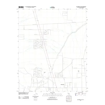
2012 Map of Victorville NW
USGS Topo · Published 2012About this map
Adelanto and the residential pocket of Shadow Hills define this high desert landscape during a period of suburban transition in the early 21st century. The map reveals a structured grid of residential streets like Fremontia Dr and El Privilegio Rd extending into the open terrain north of the city center. This area is characterized by long, straight desert roads including Shadow Mountain Rd and Drifting Sands Rd that cut across the arid environment. A significant cultural landmark, the United Islamic Youth Cem, is situated on the eastern side of the quadrangle. The topography is largely shaped by the winding course of Fremont Wash, which meanders through the northeast, providing a natural drainage contrast to the strictly linear development of the growing community.
Find a feature on this map
68 named features on this map. Tap any name to fly to it.
Don’t see what you’re looking for? This feature index may not catch every label — zoom into the map to look around manually.
Map Details
Editions of this 2012 Victorville NW Map
This is the sole edition of this map. No revisions or reprints were ever made.
Other maps of this area

1932 · Barstow
USGS Topo · 1:125,000

1934 · Barstow
USGS Topo · 1:125,000

1937 · Shadow Mountains
USGS Topo · 1:48,000

1937 · Kramer
USGS Topo · 1:48,000

1942 · Kramer
USGS Topo · 1:62,500

1942 · Shadow Mountains
USGS Topo · 1:62,500

1947 · Red Buttes
USGS Topo · 1:24,000

1953 · San Bernardino
USGS Topo · 1:250,000
1955 · Shadow Mountains
USGS Topo · 1:24,000
1955 · Shadow Mountains SE
USGS Topo · 1:24,000