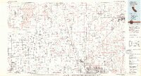
1982 Map of Victorville
USGS Topo · Published 1982About this map
George Air Force Base and Edwards Air Force Base dominate this High Desert landscape, illustrating the region's mid-century evolution into a critical aerospace and military testing hub. The presence of the NASA Flight Research Ctr and the Rocket Propulsion Laboratory underscores the area's role in cold-war era technological advancement. Beyond the runways, the map traces the vital path of the California Aqueduct and the Mojave River, showing the engineering required to sustain settlements like Victorville and Barstow in the arid Antelope Valley.
Find a feature on this map
69 named features on this map. Tap any name to fly to it.
Don’t see what you’re looking for? This feature index may not catch every label — zoom into the map to look around manually.
Map Details
Editions of this 1982 Victorville Map
2 editions found
Other maps of this area

1900 · Tujunga
USGS Topo · 1:62,500

1901 · Southern California Sheet No. 1
USGS Topo · 1:250,000

1902 · Deep Creek
USGS Topo · 1:62,500

1902 · Hesperia
USGS Topo · 1:62,500

1902 · San Gorgonio
USGS Topo · 1:125,000

1903 · Rock Creek
USGS Topo · 1:62,500

1903 · San Antonio
USGS Topo · 1:62,500

1904 · Southern California Sheet No. 1
USGS Topo · 1:250,000

1915 · Elizabeth Lake
USGS Topo · 1:125,000

1915 · Searles Lake
USGS Topo · 1:250,000