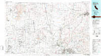
1982 Map of Victorville
USGS Topo · Published 1982About this map
Edwards Air Force Base and the NASA Flight Research Ctr dominate the northwestern landscape, centered on the dry expanse of Rogers Lake. This 1982 compilation shows a region defined by massive military and aerospace installations, including the Rocket Propulsion Laboratory and George Air Force Base near Victorville. The Mojave River valley serves as a primary corridor for transportation, carrying the Atchison Topeka and Santa Fe and Union Pacific railroads toward the desert hub of Barstow. In the high desert beyond the air bases, the map records the legacy of the Old Spanish Trail and several mining sites like the Rabbit Hole Mine and Western Mine. From the planned streets of Apple Valley to the protected land at Saddleback Butte State Park, the sheet captures the expansion of High Desert communities during the early 1980s.
Find a feature on this map
79 named features on this map. Tap any name to fly to it.
Don’t see what you’re looking for? This feature index may not catch every label — zoom into the map to look around manually.
Map Details
Editions of this 1982 Victorville Map
2 editions found
Other maps of this area

1900 · Tujunga
USGS Topo · 1:62,500

1901 · Southern California Sheet No. 1
USGS Topo · 1:250,000

1902 · Deep Creek
USGS Topo · 1:62,500

1902 · Hesperia
USGS Topo · 1:62,500

1902 · San Gorgonio
USGS Topo · 1:125,000

1903 · Rock Creek
USGS Topo · 1:62,500

1903 · San Antonio
USGS Topo · 1:62,500

1904 · Southern California Sheet No. 1
USGS Topo · 1:250,000

1915 · Elizabeth Lake
USGS Topo · 1:125,000

1915 · Searles Lake
USGS Topo · 1:250,000