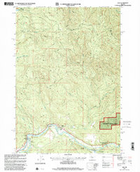
1997 Map of Vida
USGS Topo · Published 2001About this map
The MC Kenzie River carves through the southern landscape of this Oregon territory, serving as the primary corridor for settlement and recreation during the late 1990s. Near the community of Vida, the historic Goodpasture Bridge (Covered) stands as a notable landmark over the water. The river's influence on the local economy and environment is evident through features like the Leaburg Fish Hatchery and the Gaging Station, alongside public lands such as Ben and Kay Dorris State Park and Willamette National Forest.
Find a feature on this map
26 named features on this map. Tap any name to fly to it.
Don’t see what you’re looking for? This feature index may not catch every label — zoom into the map to look around manually.
Map Details
Editions of this 1997 Vida Map
This is the sole edition of this map. No revisions or reprints were ever made.
Other maps of this area

1934 · Mc Kenzie Bridge
USGS Topo · 1:96,000

1940 · Mc Kenzie Bridge
USGS Topo · 1:125,000

1951 · Sweet Home
USGS Topo · 1:62,500

1951 · Leaburg
USGS Topo · 1:62,500

1953 · Salem
USGS Topo · 1:250,000

1954 · Salem
USGS Topo · 1:250,000

1955 · Blue River
USGS Topo · 1:62,500

1955 · Cascadia
USGS Topo · 1:62,500

1960 · Salem
USGS Topo · 1:250,000

1962 · Salem
USGS Topo · 1:250,000