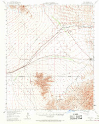
1949 Map of Vidal
USGS Topo · Published 1970About this map
Vidal and the nearby Vidal Junction serve as the primary hubs in this desert landscape, situated at a critical crossing of rail and road. The Atchison Topeka and Santa Fe railroad runs through the center of the sheet, connecting the small settlement of Grommet to the eastern corridor. This late 1940s survey reveals the vital infrastructure of the era, most notably the path of the Colorado River Aqueduct and the Blythe Vidal Road.
Find a feature on this map
18 named features on this map. Tap any name to fly to it.
Don’t see what you’re looking for? This feature index may not catch every label — zoom into the map to look around manually.
Map Details
Editions of this 1949 Vidal Map
2 editions found

Other maps of this area

1911 · Parker
USGS Topo · 1:125,000

1931 · Moon Mtn
USGS Topo · 1:62,500

1932 · Moon Mtn
USGS Topo · 1:62,500

1942 · Blythe
USGS Topo · 1:250,000

1942 · MOON MTN
USGS Topo · 1:62,500

1943 · Whipple Mts.
USGS Topo · 1:62,500

1943 · Parker
USGS Topo · 1:62,500

1943 · Turtle Mts.
USGS Topo · 1:62,500

1943 · Vidal
USGS Topo · 1:62,500

1945 · Big Maria Mtns
USGS Topo · 1:62,500