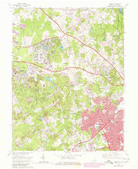
1973 Map of Vienna
USGS Topo · Published 1980About this map
The planned community of Reston and the expanding town of Vienna define this northern Virginia landscape during a period of rapid suburban maturation. Extensive residential growth is visible near Lake Anne and the USGS National Center, contrasting with the more established rural crossroads of Dranesville and Hunter. Significant green space is preserved along the Difficult Run corridor, which winds through several stream valley parks. Cultural and historical landmarks are well represented, from the Wolf Trap Farm Park and its Filene Center to the historic Colvin Run Mill. The map documents the modernization of the region's infrastructure, showing the Dulles Airport Road cutting across the terrain, alongside older thoroughfares like the Leesburg Pike and Old Georgetown Pike. This edition also captures the density of educational and civic institutions, including Madison High Sch and the Oakton High Sch.
Find a feature on this map
80 named features on this map. Tap any name to fly to it.
Don’t see what you’re looking for? This feature index may not catch every label — zoom into the map to look around manually.
Map Details
Editions of this 1973 Vienna Map
This is the sole edition of this map. No revisions or reprints were ever made.
Other maps of this area

1890 · Mt. Vernon
USGS Topo · 1:125,000

1891 · Mt. Vernon
USGS Topo · 1:125,000

1893 · Frederick
USGS Topo · 1:125,000

1894 · Frederick
USGS Topo · 1:125,000

1894 · Mt. Vernon
USGS Topo · 1:125,000

1897 · Mt. Vernon
USGS Topo · 1:125,000

1900 · Washington
USGS Topo · 1:62,500

1908 · Rockville
USGS Topo · 1:62,500

1908 · Seneca
USGS Topo · 1:62,500

1915 · Fairfax
USGS Topo · 1:62,500