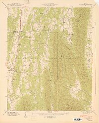
1947 Map of Villanow
USGS Topo · Published 1947About this map
The Chattahoochee National Forest dominates this mid-century landscape where Whitfield and Walker counties meet. This survey shows a post-war rural infrastructure defined by narrow mountain gaps and a series of distinct valleys, including Hurricane Valley and Furnace Valley. Small communities like Villanow, Reo, and Bailey are centered around local institutions such as Fairview School and a collection of country churches including Salem Church and Lindsey Memorial Church.
Find a feature on this map
49 named features on this map. Tap any name to fly to it.
Don’t see what you’re looking for? This feature index may not catch every label — zoom into the map to look around manually.
Map Details
Editions of this 1947 Villanow Map
2 editions found
Other maps of this area

1886 · Dalton
USGS Topo · 1:125,000

1886 · Ringgold
USGS Topo · 1:125,000

1892 · Ringgold
USGS Topo · 1:125,000

1892 · Dalton
USGS Topo · 1:125,000

1897 · Dalton
USGS Topo · 1:125,000

1935 · Catlett
USGS Topo · 1:24,000

1935 · Villanow
USGS Topo · 1:24,000

1935 · Nickajack Gap
USGS Topo · 1:24,000

1935 · Tunnel Hill
USGS Topo · 1:24,000

1938 · Chatsworth
USGS Topo · 1:48,000