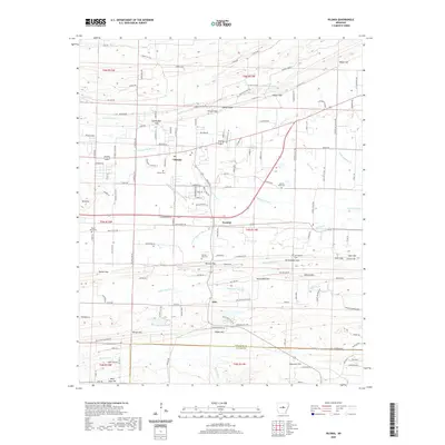
2020 Map of Vilonia
USGS Topo · Published 2020About this map
Vilonia and its surrounding rural landscapes are captured here in a transition toward residential development while maintaining deep ties to its agricultural past. The terrain is defined by a series of prominent gaps and ridges, including Cadron Ridge and Powell Gap to the north, which channel the drainage of Little Cypress Cr and the various forks of Cypress Bayou. These waterways create a complex hydrological network that has historically dictated the placement of roads and farmsteads.
Find a feature on this map
121 named features on this map. Tap any name to fly to it.
Don’t see what you’re looking for? This feature index may not catch every label — zoom into the map to look around manually.
Map Details
Editions of this 2020 Vilonia Map
This is the sole edition of this map. No revisions or reprints were ever made.
Other maps of this area

1891 · Little Rock
USGS Topo · 1:125,000

1893 · Little Rock
USGS Topo · 1:125,000

1941 · Olmstead
USGS Topo · 1:31,680

1941 · Cabot
USGS Topo · 1:31,680

1953 · Cato
USGS Topo · 1:24,000

1954 · Olmstead
USGS Topo · 1:24,000
1954 · Cabot
USGS Topo · 1:24,000

1955 · Little Rock
USGS Topo · 1:250,000

1956 · Little Rock
USGS Topo · 1:250,000

1956 · Russellville
USGS Topo · 1:250,000