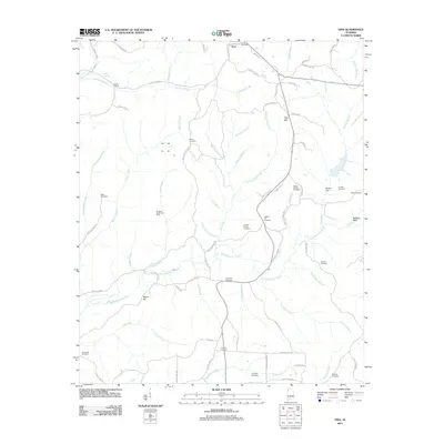
2011 Map of Vina
USGS Topo · Published 2011About this map
Vina serves as the primary hub in this corner of Franklin County, where the upper reaches of the Bull Mountain Creek and Hurricane Creek watersheds converge. The landscape is defined by a dense network of family-named landmarks and rural burial grounds, reflecting generations of local settlement. Genealogists will find a high concentration of established sites such as Miller Cemetery, Brazel Cemetery, and the Childers Family Cemetery. Industrial activity is marked by the Bluegut Creek Gas Field and Mobley Dam, while the terrain itself rises to prominent points like Pilot Hill and the distinctive Buzzard Bluff. The map provides a clear view of the rural infrastructure at the start of the 2010s, tracing the winding paths of County Hwy-23 and Vina Shottsville Rd as they navigate the area's numerous creek branches and hollows.
Find a feature on this map
88 named features on this map. Tap any name to fly to it.
Don’t see what you’re looking for? This feature index may not catch every label — zoom into the map to look around manually.
Map Details
Editions of this 2011 Vina Map
This is the sole edition of this map. No revisions or reprints were ever made.
Other maps of this area

1936 · Hodges
USGS Topo · 1:24,000

1936 · Red Bay
USGS Topo · 1:24,000

1936 · Vina
USGS Topo · 1:24,000

1936 · Halltown
USGS Topo · 1:24,000

1936 · Guinn Cross Roads
USGS Topo · 1:24,000
1946 · Guinn Cross Roads
USGS Topo · 1:24,000
1947 · Guinn Cross Roads
USGS Topo · 1:24,000

1949 · Hodges
USGS Topo · 1:24,000

1950 · Vina
USGS Topo · 1:24,000
1950 · Halltown
USGS Topo · 1:24,000