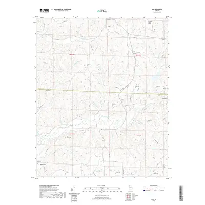
2020 Map of Vina
USGS Topo · Published 2020About this map
Vina sits at the northern edge of this landscape where the Tennessee Valley Divide splits the watershed, sending numerous creeks southward into the Bull Mountain Cr basin. The area is characterized by a dense network of family cemeteries and small rural settlements, including Atwood in the northeast and Shottsville in the southwest corner. The drainage pattern is complex, with named tributaries like Hurricane Cr, Mule Stable Br, and Loud Mill Br carving through the terrain near Moore Hill and Buzzard Bluff. Local history is deeply rooted in these small communities, as evidenced by the high concentration of burial sites such as Jones Cem, Fairview Cem, and Childers Family Cem. The boundary between Franklin Co and Marion Co cuts across the central portion of the map, dividing the land into distinct administrative townships.
Find a feature on this map
99 named features on this map. Tap any name to fly to it.
Don’t see what you’re looking for? This feature index may not catch every label — zoom into the map to look around manually.
Map Details
Editions of this 2020 Vina Map
This is the sole edition of this map. No revisions or reprints were ever made.
Other maps of this area

1936 · Hodges
USGS Topo · 1:24,000

1936 · Red Bay
USGS Topo · 1:24,000

1936 · Vina
USGS Topo · 1:24,000

1936 · Halltown
USGS Topo · 1:24,000

1936 · Guinn Cross Roads
USGS Topo · 1:24,000
1946 · Guinn Cross Roads
USGS Topo · 1:24,000
1947 · Guinn Cross Roads
USGS Topo · 1:24,000

1949 · Hodges
USGS Topo · 1:24,000

1950 · Vina
USGS Topo · 1:24,000
1950 · Halltown
USGS Topo · 1:24,000