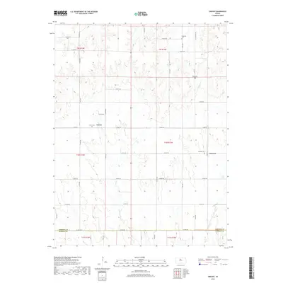
2018 Map of Vincent
USGS Topo · Published 2018About this map
The boundary between Osborne and Russell counties defines the southern reaches of this landscape, where the rural settlements of Cheyenne and Vincent anchor a region shaped by agricultural section lines and rolling topography. The land is drained by the winding courses of Fourmile Creek in the east and Coon Creek in the west, with the notable landform of Cheyenne Gap providing a break in the terrain south of Potterville Cemetery. For those tracing local history or family lineages, the presence of dedicated grounds such as Vincent Cemetery and Cheyenne Cemetery offers precise points of reference for the families who settled this part of north-central Kansas. The road network is composed primarily of alphanumeric drives and avenues, like W 300th Drive and S 130th Avenue, which reflect the modern organization of this long-established farming country.
Find a feature on this map
42 named features on this map. Tap any name to fly to it.
Don’t see what you’re looking for? This feature index may not catch every label — zoom into the map to look around manually.
Map Details
Editions of this 2018 Vincent Map
This is the sole edition of this map. No revisions or reprints were ever made.
Other maps of this area

1896 · Osborne
USGS Topo · 1:125,000

1955 · Beloit
USGS Topo · 1:250,000

1959 · Beloit
USGS Topo · 1:250,000

1978 · Osborne SW
USGS Topo · 1:24,000
1978 · Lucas
USGS Topo · 1:24,000
1978 · Luray
USGS Topo · 1:24,000
1978 · Osborne SE
USGS Topo · 1:24,000
1978 · Vincent
USGS Topo · 1:24,000
1978 · Meades Ranch
USGS Topo · 1:24,000
1978 · Waldo
USGS Topo · 1:24,000