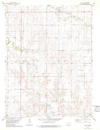
1978 Map of Waldo
USGS Topo · Published 1979About this map
Waldo serves as the primary hub in this late-1970s survey of north-central Kansas, situated where the Union Pacific railroad and state highways meet. The landscape is defined by the dendritic drainage patterns of Wolf Creek and Paradise Creek, which feed into the northern reaches of Wilson Lake at the bottom of the quadrangle. This era shows the developed utility infrastructure of the region, including a prominent pipeline and a substation near the town center. Local history interests are anchored by the Amherst Ch in the eastern portion of the map and a gaging station along Paradise Creek, illustrating the intersection of traditional community centers and modern water management. The terrain is marked by numerous small tributaries such as Waldo Creek and Boswell Creek, which highlight the intricate erosional features of the Smoky Hills region.
Find a feature on this map
11 named features on this map. Tap any name to fly to it.
Don’t see what you’re looking for? This feature index may not catch every label — zoom into the map to look around manually.
Map Details
Editions of this 1978 Waldo Map
This is the sole edition of this map. No revisions or reprints were ever made.
Other maps of this area

1896 · Osborne
USGS Topo · 1:125,000

1896 · Russell
USGS Topo · 1:125,000

1955 · Great Bend
USGS Topo · 1:250,000

1955 · Beloit
USGS Topo · 1:250,000

1957 · Great Bend
USGS Topo · 1:250,000

1958 · Great Bend
USGS Topo · 1:250,000

1959 · Beloit
USGS Topo · 1:250,000

1967 · Russell NW
USGS Topo · 1:24,000
1967 · Dorrance NW
USGS Topo · 1:24,000

1967 · Russell
USGS Topo · 1:24,000