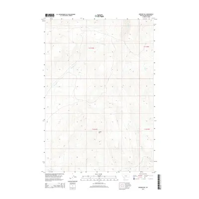
2014 Map of Vinegar Hill
USGS Topo · Published 2014About this map
Vinegar Hill rises as the central landmark in this high-altitude section of Beaverhead County, defining a landscape shaped by narrow drainages and mountain springs. The terrain is intricately carved by several seasonal and perennial waterways, including the north-flowing Teddy Cr and the westward-reaching Little Sage Cr. In the northern reaches, Box Springs and Price Cr indicate vital water sources in an otherwise arid environment. This 2014 survey reveals a territory primarily organized by the Public Land Survey System, with township and range lines such as t12s r7w and t11s r7w providing the only human-imposed structure across the open ground. The concentration of named creeks like Basin Cr at the southern margin suggests a topography where life and movement have historically followed these vital water corridors through the high country.
Find a feature on this map
10 named features on this map. Tap any name to fly to it.
Don’t see what you’re looking for? This feature index may not catch every label — zoom into the map to look around manually.
Map Details
Editions of this 2014 Vinegar Hill Map
This is the sole edition of this map. No revisions or reprints were ever made.
Other maps of this area

1955 · Dubois
USGS Topo · 1:250,000

1958 · Dubois
USGS Topo · 1:250,000

1965 · Lima
USGS Topo · 1:24,000

1965 · Rock Island Ranch
USGS Topo · 1:24,000
1965 · Beech Creek
USGS Topo · 1:24,000
1968 · Price Creek
USGS Topo · 1:24,000

1968 · Whiskey Spring
USGS Topo · 1:24,000

1968 · Lima Dam
USGS Topo · 1:24,000
1968 · Price Creek NE
USGS Topo · 1:24,000

1968 · Vinegar Hill
USGS Topo · 1:24,000