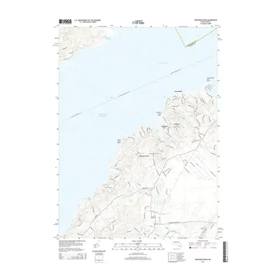
2015 Map of Vineyard Haven
USGS Topo · Published 2015About this map
Vineyard Sound and the Atlantic Ocean frame the north and west of this coastal Martha’s Vineyard landscape, where freshwater and saltwater ecosystems meet. The interior is defined by a complex drainage system, including the southward flow of Mill Brook through Old Millpond and several smaller basins like Priester Pond and Fisher Pond before reaching Tisbury Great Pond. Settlement patterns are visible in the clusters at Makonikey, Longview, and Christian Town, the latter of which serves as a poignant reminder of local heritage with the Christiantown Memorial Cem. Further south, the West-Tisbury Village Cem marks the northern edge of West Tisbury's developed areas. The map details a web of coastal access points such as Lamberts Cove and North Shore Beach, while the Martha's Vineyard Fast Fry ferry route establishes the modern connection to the mainland across the sound.
Find a feature on this map
115 named features on this map. Tap any name to fly to it.
Don’t see what you’re looking for? This feature index may not catch every label — zoom into the map to look around manually.
Map Details
Editions of this 2015 Vineyard Haven Map
This is the sole edition of this map. No revisions or reprints were ever made.
Other maps of this area

1885 · New Bedford
USGS Topo · 1:62,500

1886 · Falmouth
USGS Topo · 1:62,500

1887 · Gay Head
USGS Topo · 1:62,500

1887 · Marthas Vineyard
USGS Topo · 1:62,500

1888 · New Bedford
USGS Topo · 1:62,500

1888 · Falmouth
USGS Topo · 1:62,500

1889 · Gay Head
USGS Topo · 1:62,500

1889 · Marthas Vineyard
USGS Topo · 1:62,500

1893 · Gay Head
USGS Topo · 1:62,500

1893 · Falmouth
USGS Topo · 1:62,500