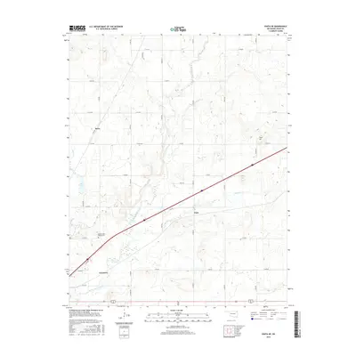
2016 Map of Vinita NE
USGS Topo · Published 2016About this map
Little Cabin Creek and its many tributaries, including Possum Br and Shawnee Cr, define the drainage patterns of this Craig County landscape. Small rural clusters like Kelso, Todd, and Cornatzar anchor the section-line road network, reflecting the traditional agricultural layout of northeastern Oklahoma. A significant point of interest for local historians is the Eastern State Hospital Cem, located just south of the creek's bend. The terrain rises to notable elevations at Goat Hill, providing a topographical contrast to the low-lying waters of Bull Lake and the winding course of Jones Cr. This modern survey documents the persistent rural character of the region, where named landmarks and family-scale topography remain central to the local identity.
Find a feature on this map
32 named features on this map. Tap any name to fly to it.
Don’t see what you’re looking for? This feature index may not catch every label — zoom into the map to look around manually.
Map Details
Editions of this 2016 Vinita NE Map
This is the sole edition of this map. No revisions or reprints were ever made.
Other maps of this area

1901 · Vinita
USGS Topo · 1:125,000

1907 · Wyandotte
USGS Topo · 1:125,000

1909 · Wyandotte
USGS Topo · 1:125,000

1913 · Vinita
USGS Topo · 1:125,000

1954 · Tulsa
USGS Topo · 1:250,000

1958 · Tulsa
USGS Topo · 1:250,000

1961 · Miami SW
USGS Topo · 1:24,000

1963 · Tulsa
USGS Topo · 1:250,000
1971 · Pyramid Corners
USGS Topo · 1:24,000
1971 · Big Cabin
USGS Topo · 1:24,000