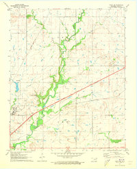
1971 Map of Vinita NE
USGS Topo · Published 1973About this map
Eastern Oklahoma State Hospital dominates the western landscape of this Craig County region, its expansive grounds and infrastructure—including a Water Tank and Sewage Disposal system—bounded by a distinct Hospital Boundary. The area serves as a significant transportation corridor where the Will Rogers Turnpike cuts diagonally across the terrain, intersecting the natural path of Little Cabin Creek. This drainage system, fed by tributaries like Possum Branch and Coal Creek, shapes the low-lying valley between the high ground at Goat Hill and the surrounding prairies.
Find a feature on this map
22 named features on this map. Tap any name to fly to it.
Don’t see what you’re looking for? This feature index may not catch every label — zoom into the map to look around manually.
Map Details
Editions of this 1971 Vinita NE Map
This is the sole edition of this map. No revisions or reprints were ever made.
Other maps of this area

1901 · Vinita
USGS Topo · 1:125,000

1907 · Wyandotte
USGS Topo · 1:125,000

1909 · Wyandotte
USGS Topo · 1:125,000

1913 · Vinita
USGS Topo · 1:125,000

1954 · Tulsa
USGS Topo · 1:250,000

1958 · Tulsa
USGS Topo · 1:250,000

1961 · Miami SW
USGS Topo · 1:24,000

1963 · Tulsa
USGS Topo · 1:250,000
1971 · Pyramid Corners
USGS Topo · 1:24,000
1971 · Big Cabin
USGS Topo · 1:24,000