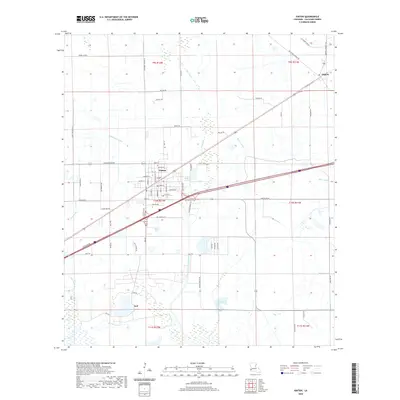
2020 Map of Vinton
USGS Topo · Published 2020About this map
Vinton serves as the central hub of this Calcasieu Parish landscape, where residential blocks and industrial sites meet the vast drainage network of southwestern Louisiana. The terrain is defined by a sophisticated system of water management, featuring the Sabine Canal and Vinton Drainage Canal alongside natural waterways like Hampton Coulee, Coon Gully, and Gum Gully. To the east, the settlement of Edgerly sits near the junction of several rural routes, while the smaller community of Ged is located further south near Ged Lake. The mapping reveals a transition from the concentrated grid of Vinton to the surrounding agricultural and industrial parcels, connected by family-named roads such as Johnny Breaux Rd and Leo Breaux Rd, which suggest long-standing local land ownership and lineage in the region.
Find a feature on this map
71 named features on this map. Tap any name to fly to it.
Don’t see what you’re looking for? This feature index may not catch every label — zoom into the map to look around manually.
Map Details
Editions of this 2020 Vinton Map
This is the sole edition of this map. No revisions or reprints were ever made.
Other maps of this area

1932 · Orange
USGS Topo · 1:62,500

1946 · Phoenix Lake
USGS Topo · 1:31,680

1947 · Sulphur
USGS Topo · 1:31,680

1947 · Starks
USGS Topo · 1:31,680

1947 · Vinton
USGS Topo · 1:31,680

1947 · Toomey
USGS Topo · 1:31,680

1947 · Sulphur Mines
USGS Topo · 1:31,680

1947 · Lunita
USGS Topo · 1:31,680
1949 · Cameron Farms
USGS Topo · 1:31,680
1949 · Black Lake
USGS Topo · 1:31,680