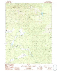
1986 Map of Viola
USGS Topo · Published 1986About this map
Viola and its surrounding ranchlands sit at the intersection of managed timberlands and water resources in mid-1980s Shasta County. The landscape is defined by the high elevations of the Latour Demonstration State Forest, featuring distinctive geological landmarks like Mushroom Rock, Rooster Comb, and Latour Butte. A network of 4WD trails connects remote homesteads such as Bateman Place and Beal Place with the larger cattle operations like Armstrong Ranch and Hootman Ranch. Water management is central to the area's geography, shown through the North Battle Creek Reservoir and McCumber Reservoir, which regulate the flow of the North Fork Battle Creek. These reservoirs, along with Camp McCumber, indicate the region's dual role as a utility corridor and a destination for summer recreation. To the east, the boundary of Lassen National Forest begins, marked by the narrow drainage of Manzanita Chute.
Find a feature on this map
37 named features on this map. Tap any name to fly to it.
Don’t see what you’re looking for? This feature index may not catch every label — zoom into the map to look around manually.
Map Details
Editions of this 1986 Viola Map
This is the sole edition of this map. No revisions or reprints were ever made.
Other maps of this area

1886 · Lassen Peak
USGS Topo · 1:250,000

1892 · Lassen Peak
USGS Topo · 1:250,000

1894 · Lassen Peak
USGS Topo · 1:250,000

1935 · Burney
USGS Topo · 1:96,000

1935 · Paynes Creek
USGS Topo · 1:96,000

1939 · Burney
USGS Topo · 1:125,000

1941 · Mineral
USGS Topo · 1:125,000

1955 · Westwood
USGS Topo · 1:250,000

1956 · Lassen Peak
USGS Topo · 1:62,500

1956 · Manton
USGS Topo · 1:62,500