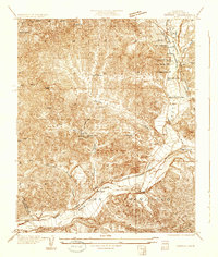
1937 Map of Violin Canyon
USGS Topo · Published 1937About this map
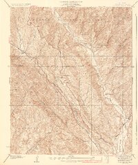
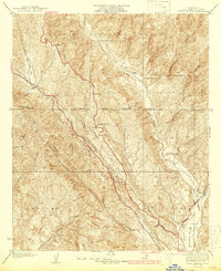
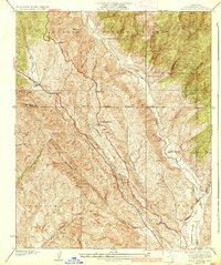
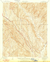
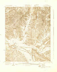
Cordova Ranch and Davies Ranch sit within a landscape of deeply etched drainages and sharp ridges in the northern reaches of Los Angeles County. During the late 1930s, this area of the Angeles National Forest served as a vital corridor for both transportation and utilities. The map shows Route No 99 and Transmission Lines cutting through Violin Canyon and Marple Canyon, following the natural contours of the terrain toward the Castaic Valley. An Airway Beacon positioned near the First Standard Parallel North highlights the era's growing dependence on aerial navigation markers. The convergence of Castaic Creek and Elizabeth Lake Canyon reveals a complex network of seasonal watercourses, where small settlements like Martins managed to take root along the primary travel routes between the central valley and the Los Angeles basin.
Find a feature on this map
25 named features on this map. Tap any name to fly to it.
Don’t see what you’re looking for? This feature index may not catch every label — zoom into the map to look around manually.
Map Details
Editions of this 1937 Violin Canyon Map
4 editions found
Other maps of this area

1903 · Tejon
USGS Topo · 1:125,000

1903 · Camulos
USGS Topo · 1:125,000

1903 · Santa Susana
USGS Topo · 1:62,500
1929 · Saugus
USGS Topo · 1:24,000
1931 · Red Mountain
USGS Topo · 1:24,000
1931 · Whitaker Peak
USGS Topo · 1:24,000
1931 · Warm Spring
USGS Topo · 1:24,000

1931 · Santa Felicia Canyon
USGS Topo · 1:24,000
1931 · Castaic
USGS Topo · 1:24,000
1931 · Redrock Mtn
USGS Topo · 1:24,000