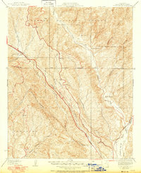
1937 Map of Violin Canyon
USGS Topo · Published 1951About this map
Golden State Highway and the Old Ridge Route dominate this 1937 survey of the Los Angeles County backcountry, showing the evolution of North-South transit through the steep canyons of the Angeles National Forest. The map, revised in 1950, captures a mid-century landscape where isolated outposts like Paradise Ranch and Martins served travelers and locals before modern interstate expansion. Along the eastern edge, Castaic Creek and Elizabeth Lake Canyon carve deep paths through the terrain, flanked by family landmarks such as Cordova Ranch and Daries Ranch. The engineering of the era is evident in the Marple Transmission Line cutting across Violin Canyon and the First Standard Parallel North. This topography reveals the sparse settlement patterns of the Temascal area, defined by cattle ranching and early utility infrastructure before the region’s suburbanization.
Find a feature on this map
24 named features on this map. Tap any name to fly to it.
Don’t see what you’re looking for? This feature index may not catch every label — zoom into the map to look around manually.
Map Details
Editions of this 1937 Violin Canyon Map
4 editions found
Other maps of this area

1903 · Tejon
USGS Topo · 1:125,000

1903 · Camulos
USGS Topo · 1:125,000

1903 · Santa Susana
USGS Topo · 1:62,500

1929 · Saugus
USGS Topo · 1:24,000

1931 · Red Mountain
USGS Topo · 1:24,000

1931 · Whitaker Peak
USGS Topo · 1:24,000

1931 · Warm Spring
USGS Topo · 1:24,000

1931 · Santa Felicia Canyon
USGS Topo · 1:24,000

1931 · Castaic
USGS Topo · 1:24,000

1931 · Redrock Mtn
USGS Topo · 1:24,000