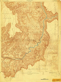
1907 Map of Vishnu
USGS Topo · Published 1919About this map
Vishnu Temple and the towering architecture of the inner gorge dominate this early 20th-century topographic record of the canyon's heart. Surveyed just after the turn of the century by Francois E. Matthes and Richard T. Evans, the map documents a landscape before the era of mass tourism, focusing on the junction of the Colorado River and the Little Colorado River. Early settlement footprints are sparse but significant, including the Hance Ranch and a lonely Cabin on the eastern plateaus. The topography is meticulously detailed, tracing the descent from the Walhalla Plateau down through the Basalt Cliffs to the churning Hance Rapids. Historically significant routes like the Tonto Trail and Tanner Trail are mapped as thin threads through the immense terrain, while family-named landmarks like Newberry Butte and Cardenas Butte identify the landforms for early explorers and geologists.
Find a feature on this map
75 named features on this map. Tap any name to fly to it.
Don’t see what you’re looking for? This feature index may not catch every label — zoom into the map to look around manually.
Map Details
Editions of this 1907 Vishnu Map
3 editions found

Other maps of this area

1886 · San Francisco Mtns
USGS Topo · 1:250,000

1886 · Chino
USGS Topo · 1:250,000

1886 · Echo Cliffs
USGS Topo · 1:250,000

1886 · Kaibab
USGS Topo · 1:250,000

1891 · San Francisco Mtns
USGS Topo · 1:250,000

1891 · Chino
USGS Topo · 1:250,000

1891 · Echo Cliffs
USGS Topo · 1:250,000

1894 · San Francisco Mtns
USGS Topo · 1:250,000

1899 · San Francisco Mtns
USGS Topo · 1:250,000

1903 · Bright Angel
USGS Topo · 1:48,000