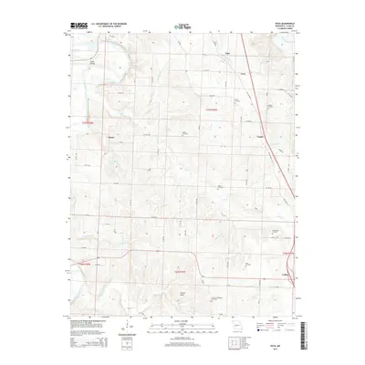
2015 Map of Vista
USGS Topo · Published 2015About this map
Collins and Vista anchor this portion of St. Clair County, where the Ozark landscape meets the drainage basins of the Sac River and Coon Creek. The map reveals a dense network of rural cemeteries, including Allen Cemetery, Culbertson Cemetery, and Freeman-Holsapple Cemetery, which serve as vital touchstones for family historians and genealogists tracking the area's early residents. The terrain is marked by distinctive landmarks such as Shryers Bluff along the Cannon Branch and the prominent waters of Coleman Lake. Small clusters of settlement at Tracy, Raney, and Topper are connected by a grid of rural routes and the alignment of Old Highway 13. The mapping of numerous creek branches, such as Rattlesnake Branch and Southwick Branch, illustrates the complex hydrography that has shaped the agriculture and placement of homesteads in this Missouri countryside.
Find a feature on this map
50 named features on this map. Tap any name to fly to it.
Don’t see what you’re looking for? This feature index may not catch every label — zoom into the map to look around manually.
Map Details
Editions of this 2015 Vista Map
This is the sole edition of this map. No revisions or reprints were ever made.
Other maps of this area

1886 · Stockton
USGS Topo · 1:125,000

1887 · Clinton
USGS Topo · 1:125,000

1894 · Clinton
USGS Topo · 1:125,000

1938 · Monegaw Springs
USGS Topo · 1:24,000

1938 · Roscoe
USGS Topo · 1:24,000

1938 · Vista
USGS Topo · 1:24,000

1939 · Caplinger Mills
USGS Topo · 1:24,000

1939 · Osceola
USGS Topo · 1:24,000

1939 · Arnica
USGS Topo · 1:24,000

1940 · Roscoe
USGS Topo · 1:24,000