
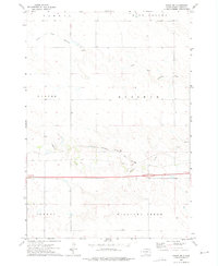
1972 Map of Vivian
USGS Topo · Published 1975About this map
The settlement of Vivian serves as a central hub in this mid-1970s Lyman County landscape, situated where the Chicago Milwaukee St Paul and Pacific railroad intersects major transit corridors. The map details a transition in transportation, showing the proximity of the rail line to the newer infrastructure of Interstate 90 and U.S. Highway 83. North of the town center, the Vivian Cem and local Gravel Pits indicate the community's local footprint.
Find a feature on this map
19 named features on this map. Tap any name to fly to it.
Don’t see what you’re looking for? This feature index may not catch every label — zoom into the map to look around manually.
Map Details
Editions of this 1972 Vivian Map
This is the sole edition of this map. No revisions or reprints were ever made.
Other maps of this area

1954 · Pierre
USGS Topo · 1:250,000

1955 · Martin
USGS Topo · 1:250,000

1958 · Pierre
USGS Topo · 1:250,000

1958 · Martin
USGS Topo · 1:250,000

1967 · Ft. George Butte SW
USGS Topo · 1:24,000

1970 · Vivian SW
USGS Topo · 1:24,000

1972 · Pierre 3 SW
USGS Topo · 1:24,000

1972 · Pierre 3 SE
USGS Topo · 1:24,000

1972 · Vivian SE
USGS Topo · 1:24,000
1972 · Vivian NW
USGS Topo · 1:24,000