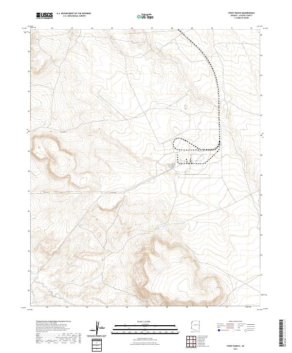
2021 Map of Voigt Ranch
USGS Topo · Published 2021About this map
Voigt Ranch sits within a landscape defined by the shifting drainage of Coyote Creek, as documented in this 2021 topographic study of Apache County. The terrain is a network of intermittent watercourses and small springs, such as Stamps Spring, that suggest the seasonal rhythms of ranching life in this part of Arizona. The map illustrates a sparse but functional infrastructure of local routes, including Co Rd 4265 and Co Rd 4162, which connect the isolated homesteads to the wider region. This record of the Public Land Survey System shows the township and range divisions of T11N and T10N, providing a clear view of land management and property boundaries in a high-desert environment where water sources like Coyote Cr are the primary landmarks.
Find a feature on this map
10 named features on this map. Tap any name to fly to it.
Don’t see what you’re looking for? This feature index may not catch every label — zoom into the map to look around manually.
Map Details
Editions of this 2021 Voigt Ranch Map
This is the sole edition of this map. No revisions or reprints were ever made.
Other maps of this area

1886 · St Johns
USGS Topo · 1:250,000

1892 · St Johns
USGS Topo · 1:250,000

1954 · Saint Johns
USGS Topo · 1:250,000

1957 · Saint Johns
USGS Topo · 1:250,000

1958 · Saint Johns
USGS Topo · 1:250,000

1962 · Saint Johns
USGS Topo · 1:250,000
1968 · Nelson Reservoir NE
USGS Topo · 1:24,000

1969 · Coyote Hills
USGS Topo · 1:24,000
1969 · Springerville
USGS Topo · 1:24,000

1971 · Mesa Parada NW
USGS Topo · 1:24,000