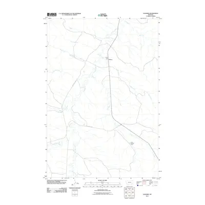
2011 Map of Volborg
USGS Topo · Published 2011About this map
The Volborg Post Office serves as the central hub of this eastern Montana ranching landscape, situated where several prominent drainages converge. The topography is defined by the winding path of Pumpkin Creek, which is joined by numerous tributaries including Prairie Dog Creek, Ranch Creek, and S L Creek. This network of seasonal waterways and coulees, such as Sand Coulee, illustrates the drainage patterns vital to livestock operations in Custer County. Transport across this open country relies on a few primary routes like Stacy-Sonnette Rd and Big Pumpkin Creek Rd. The presence of the Allen Number 6 Dam highlights the importance of water management in a region where creeks like Lone Tree Creek and Shelter Creek cross the arid plains.
Find a feature on this map
15 named features on this map. Tap any name to fly to it.
Don’t see what you’re looking for? This feature index may not catch every label — zoom into the map to look around manually.
Map Details
Editions of this 2011 Volborg Map
This is the sole edition of this map. No revisions or reprints were ever made.
Other maps of this area

1954 · Ekalaka
USGS Topo · 1:250,000

1956 · Ekalaka
USGS Topo · 1:250,000

1958 · Ekalaka
USGS Topo · 1:250,000

1965 · Ekalaka
USGS Topo · 1:250,000

1966 · Elk Ridge
USGS Topo · 1:24,000
1973 · Harris Buttes
USGS Topo · 1:24,000
1973 · Carey-Malone School
USGS Topo · 1:24,000
1973 · Kirkpatrick Hill
USGS Topo · 1:24,000

1973 · Box Elder Creek
USGS Topo · 1:24,000

1973 · Coalwood
USGS Topo · 1:24,000