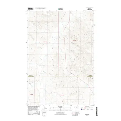
2017 Map of Volborg
USGS Topo · Published 2017About this map
Volborg sits at the junction of Highway 59 and Shelter Cr, serving as a central point in this stretch of eastern Montana ranching country. The landscape is defined by the winding course of Pumpkin Cr, which dominates the central drainage, joined by numerous tributaries including Ranch Cr and Flat Butte Cr. This 2017 survey details the complex network of rural roads that connect these remote homesteads and grazing lands, such as Stacy-Sonnette Rd and Pumpkin Creek Rd. The boundary between Custer County and Powder River County runs through the southern portion of the map, illustrating the administrative divisions of this sparsely populated region. Smaller drainages like Prairie Dog Cr and Deer Cr reveal the intricate topography of the coulees and draws typical of the Missouri Plateau.
Find a feature on this map
22 named features on this map. Tap any name to fly to it.
Don’t see what you’re looking for? This feature index may not catch every label — zoom into the map to look around manually.
Map Details
Editions of this 2017 Volborg Map
This is the sole edition of this map. No revisions or reprints were ever made.
Other maps of this area

1954 · Ekalaka
USGS Topo · 1:250,000

1956 · Ekalaka
USGS Topo · 1:250,000

1958 · Ekalaka
USGS Topo · 1:250,000

1965 · Ekalaka
USGS Topo · 1:250,000

1966 · Elk Ridge
USGS Topo · 1:24,000
1973 · Harris Buttes
USGS Topo · 1:24,000
1973 · Carey-Malone School
USGS Topo · 1:24,000
1973 · Kirkpatrick Hill
USGS Topo · 1:24,000

1973 · Box Elder Creek
USGS Topo · 1:24,000

1973 · Coalwood
USGS Topo · 1:24,000