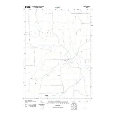
2010 Map of Volga
USGS Topo · Published 2010About this map
The Volga River carves a winding path through the center of this Clayton County landscape, anchoring the settlement of Volga. This 2010 survey illustrates a rural community shaped by its waterways and local topography, from the prominent Pilot Knob to the deep incisions of German Hollow and Hells Hollow. The township’s social history is preserved in its scattered burial grounds, including the Duff Cemetery and the Rothfusz Cemetery, alongside the uniquely named Sacred Heart- Schoolhouse Yard Cemetery. Near the town center, the Volga Post Office and Stone School Cemetery stand as primary landmarks. The map also captures the smaller locale of Thomasville to the south, where Ensign Creek meets the local road network, providing a clear record of the area's modern rural composition and its historical burial sites.
Find a feature on this map
45 named features on this map. Tap any name to fly to it.
Don’t see what you’re looking for? This feature index may not catch every label — zoom into the map to look around manually.
Map Details
Editions of this 2010 Volga Map
This is the sole edition of this map. No revisions or reprints were ever made.
Other maps of this area

1901 · Oelwein
USGS Topo · 1:125,000

1902 · Elkader
USGS Topo · 1:125,000

1959 · Dubuque
USGS Topo · 1:250,000

1961 · Dubuque
USGS Topo · 1:250,000

1962 · Dubuque
USGS Topo · 1:250,000

1964 · Edgewood
USGS Topo · 1:24,000
1964 · Elkader
USGS Topo · 1:24,000
1965 · Saint Olaf
USGS Topo · 1:24,000

1965 · Elgin
USGS Topo · 1:24,000

1965 · Wadena
USGS Topo · 1:24,000