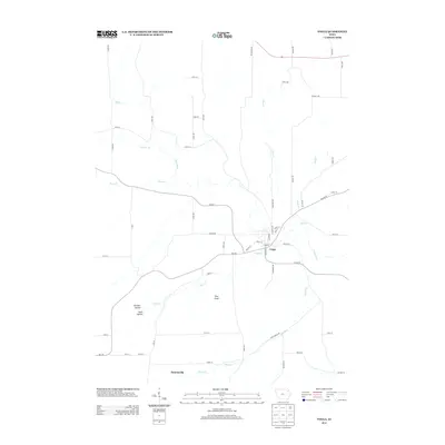
2013 Map of Volga
USGS Topo · Published 2013About this map
Volga sits at a prominent bend of the Volga River, serving as the primary hub for this portion of Clayton County. The town's grid is defined by streets such as Washington St and Buchanan St, with Nagle Creek flowing through its southern edge. Southward lies the smaller settlement of Thomasville near Ensign Creek. The landscape transitions from the river valley to higher ground marked by features such as Pilot Knob and the striking topography of German Hollow and Hells Hollow. This 2013 survey illustrates the enduring rural structure of the region, where a dense network of local roads like Bixby Ave and Acre Rd connects isolated farmsteads and agricultural tracts. A complex drainage system including Mink Creek, Hewett Creek, and Deep Creek feeds into the main river, shaping the undulating terrain and historical settlement patterns of the area.
Find a feature on this map
58 named features on this map. Tap any name to fly to it.
Don’t see what you’re looking for? This feature index may not catch every label — zoom into the map to look around manually.
Map Details
Editions of this 2013 Volga Map
This is the sole edition of this map. No revisions or reprints were ever made.
Other maps of this area

1901 · Oelwein
USGS Topo · 1:125,000

1902 · Elkader
USGS Topo · 1:125,000

1959 · Dubuque
USGS Topo · 1:250,000

1961 · Dubuque
USGS Topo · 1:250,000

1962 · Dubuque
USGS Topo · 1:250,000

1964 · Edgewood
USGS Topo · 1:24,000
1964 · Elkader
USGS Topo · 1:24,000
1965 · Saint Olaf
USGS Topo · 1:24,000

1965 · Elgin
USGS Topo · 1:24,000

1965 · Wadena
USGS Topo · 1:24,000