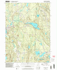
2001 Map of Voluntown
USGS Topo · Published 2003About this map
Pachaug State Forest dominates this landscape along the border of Connecticut and Rhode Island, preserving a dense network of wetlands and wooded hills. The large expanse of Beach Pond serves as a central landmark, straddling the state line between Voluntown and Exeter. Regional history is etched into the terrain through legacy routes like the Shetucket Turnpike and the Narragansett Trail, which connect dispersed settlements such as Escoheag Hill and Pendleton Hill. For those researching local families, the map identifies small, remote burial sites including Kennedy Cem and Robbins Cem. The eastern portion transition into the Arcadia State Management Area, where features like Stepstone Falls and Upper Deep Hole along the Wood River highlight the area's natural hydrology and early conservation efforts.
Find a feature on this map
52 named features on this map. Tap any name to fly to it.
Don’t see what you’re looking for? This feature index may not catch every label — zoom into the map to look around manually.
Map Details
Editions of this 2001 Voluntown Map
This is the sole edition of this map. No revisions or reprints were ever made.
Other maps of this area

1889 · Stonington
USGS Topo · 1:62,500

1889 · Charlestown
USGS Topo · 1:62,500

1889 · Moosup
USGS Topo · 1:62,500

1890 · Kent
USGS Topo · 1:62,500

1893 · Moosup
USGS Topo · 1:62,500

1893 · Stonington
USGS Topo · 1:62,500

1894 · Kent
USGS Topo · 1:62,500

1919 · Charlestown
USGS Topo · 1:62,500

1920 · Moosup
USGS Topo · 1:62,500

1921 · Charlestown
USGS Topo · 1:62,500