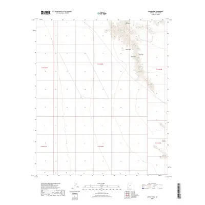
2018 Map of Vopoki Ridge
USGS Topo · Published 2018About this map
The Gila Mountains dominate the northeastern corner of this Yuma County landscape, rising sharply above the expansive arid lowlands. This survey illustrates the stark transition between the mountain massif and the surrounding flatlands, most notably at the Vopoki Ridge, which extends southeastward from the main range. Between these prominent elevations lies Spook Canyon, a natural drainage feature that cuts through the northern highland area. To the south and east, the terrain levels out into the Davis Plain, while the very southeastern edge of the map captures the northern tips of the Butler Mountains. The layout of the township and range lines, including t11s r20w and t12s r20w, reveals the systematic partitioning of this high-desert environment in the modern era.
Find a feature on this map
11 named features on this map. Tap any name to fly to it.
Don’t see what you’re looking for? This feature index may not catch every label — zoom into the map to look around manually.
Map Details
Editions of this 2018 Vopoki Ridge Map
This is the sole edition of this map. No revisions or reprints were ever made.
Other maps of this area

1926 · Fortuna
USGS Topo · 1:62,500

1926 · Wellton
USGS Topo · 1:62,500

1929 · Fortuna
USGS Topo · 1:62,500

1929 · Wellton
USGS Topo · 1:62,500

1942 · Yuma
USGS Topo · 1:250,000

1954 · El Centro
USGS Topo · 1:250,000

1955 · El Centro
USGS Topo · 1:250,000

1958 · El Centro
USGS Topo · 1:250,000

1961 · El Centro
USGS Topo · 1:250,000

1964 · El Centro
USGS Topo · 1:250,000