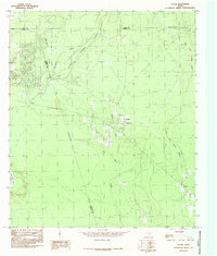
1984 Map of Votaw
USGS Topo · Published 1985About this map
The Big Thicket National Preserve dominates this portion of the East Texas piney woods, representing a landscape where dense forest meets a complex network of wetlands and waterways. Surveyed in the late 1970s and early 1980s, the map highlights the small rural settlements of Votaw and Fuqua, which developed alongside the timber and rail corridors of Hardin and Liberty counties. The hydrology of the area is particularly intricate, defined by the winding course of Pine Island Bayou and its numerous tributaries such as Beaver Creek and Menard Creek. While much of the terrain is characterized by low-lying areas like Wild Cow Marsh, human activity is evident in the scattered clearings and the industrial presence of a Gravel Pit near the center of the sheet. This provisional survey captures the region as conservation efforts were formally protecting the unique biological diversity of the Big Thicket while established communities like Thicket maintained their footprint in the deep woods.
Find a feature on this map
16 named features on this map. Tap any name to fly to it.
Don’t see what you’re looking for? This feature index may not catch every label — zoom into the map to look around manually.
Map Details
Editions of this 1984 Votaw Map
This is the sole edition of this map. No revisions or reprints were ever made.
Other maps of this area

1943 · Liberty
USGS Topo · 1:125,000

1954 · Beaumont
USGS Topo · 1:250,000

1955 · Saratoga
USGS Topo · 1:62,500

1955 · Rayburn
USGS Topo · 1:62,500

1957 · Beaumont
USGS Topo · 1:250,000

1958 · Livingston
USGS Topo · 1:62,500

1958 · Segno
USGS Topo · 1:62,500

1984 · Segno
USGS Topo · 1:24,000

1984 · Beaumont
USGS Topo · 1:250,000

1984 · Jacks Creek South
USGS Topo · 1:24,000