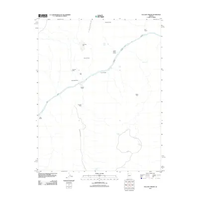
2011 Map of Vulcans Throne
USGS Topo · Published 2011About this map
Vulcans Throne dominates the northern reaches of this topographic study, standing as a prominent landmark within the Grand Canyon National Park boundaries. This section of the canyon is defined by the dramatic descent into the Colorado River, where the legendary Lava Falls and Lava Falls Rapids create some of the most powerful whitewater in the system. The geography is a complex arrangement of verticality and flat-topped formations, including the Esplanade Bench and Toroweap Point, which offer massive overlooks into the inner gorge. Evidence of the region's volcanic past is etched into the names themselves, from the dark cinder cone of the throne to the Lava Pinnacle further downstream. Moving away from the river, the landscape transitions into the wide Toroweap Valley and the intermittent Toroweap Lake, illustrating the stark contrast between the river's path and the arid plateaus above. Further south, man-made features like Mustang Tank and Elk Tank mark the presence of cattle or wildlife management along the BIA Hwy 11.
Find a feature on this map
26 named features on this map. Tap any name to fly to it.
Don’t see what you’re looking for? This feature index may not catch every label — zoom into the map to look around manually.
Map Details
Editions of this 2011 Vulcans Throne Map
This is the sole edition of this map. No revisions or reprints were ever made.
Other maps of this area

1886 · Mt. Trumbull
USGS Topo · 1:250,000

1886 · Kaibab
USGS Topo · 1:250,000

1892 · Mt. Trumbull
USGS Topo · 1:250,000

1953 · Grand Canyon
USGS Topo · 1:250,000

1957 · Grand Canyon
USGS Topo · 1:250,000

1958 · Grand Canyon
USGS Topo · 1:250,000

1960 · Grand Canyon
USGS Topo · 1:250,000

1962 · Tuckup Canyon
USGS Topo · 1:62,500

1962 · National Canyon
USGS Topo · 1:62,500
1967 · Vulcans Throne
USGS Topo · 1:24,000