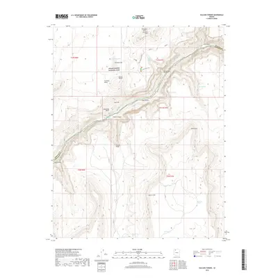
2018 Map of Vulcans Throne
USGS Topo · Published 2018About this map
Grand Canyon National Park dominates this terrain where the Colorado River carves through the landscape below the Aubrey Cliffs. The topographic survey highlights the striking verticality of the region, from the high desert floor of Prospect Valley to the dramatic volcanic landform of Vulcans Throne. This cinder cone overlooks the canyon near Lava Falls, a renowned rapid on the river. The map details the transition from the wide Toroweap Valley to the narrow, steep-walled gorges of Saddle Horse Canyon and Cove Canyon. Further south, the landscape levels into the Esplanade Bench before dropping into Prospect Canyon. Remote water sources such as Hogan Spring, Honda Springs, and Toroweap Lake provide critical points of reference in this arid environment, while the boundary between Mohave and Coconino counties follows the jagged path of the river and canyon rim.
Find a feature on this map
36 named features on this map. Tap any name to fly to it.
Don’t see what you’re looking for? This feature index may not catch every label — zoom into the map to look around manually.
Map Details
Editions of this 2018 Vulcans Throne Map
This is the sole edition of this map. No revisions or reprints were ever made.
Other maps of this area

1886 · Mt. Trumbull
USGS Topo · 1:250,000

1886 · Kaibab
USGS Topo · 1:250,000

1892 · Mt. Trumbull
USGS Topo · 1:250,000

1953 · Grand Canyon
USGS Topo · 1:250,000

1957 · Grand Canyon
USGS Topo · 1:250,000

1958 · Grand Canyon
USGS Topo · 1:250,000

1960 · Grand Canyon
USGS Topo · 1:250,000

1962 · Tuckup Canyon
USGS Topo · 1:62,500

1962 · National Canyon
USGS Topo · 1:62,500
1967 · Vulcans Throne
USGS Topo · 1:24,000