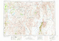
1954 Map of Vya
USGS Topo · Published 1973About this map
The Sheldon National Antelope Refuge dominates the northwestern high desert of this survey, a landscape defined by seasonal lakes and internal drainage basins like Massacre Lake and Boulder Lake. In the mid-1950s, the isolated settlement of Vya stood as a remote hub in the Long Valley corridor, while Soldier Meadow served the ranching country at the foot of the Calico Mountains. This is a land of massive, north-south trending mountain blocks and expansive playas, where the Black Rock Desert and the Black Rock Range divide the geography. The map traces the early 20th-century boundaries of the Summit Lake Indian Reservation and the Fort Mc Dermitt Indian Reservation, preserving the location of vital water sources such as Rock Spring Table Reservoir and Big Spring Reservoir in a territory where the Quinn River represents the primary hydrological artery.
Find a feature on this map
165 named features on this map. Tap any name to fly to it.
Don’t see what you’re looking for? This feature index may not catch every label — zoom into the map to look around manually.
Map Details
Editions of this 1954 Vya Map
3 editions found

Other maps of this area

1882 · Paradise
USGS Topo · 1:250,000

1886 · Alturas
USGS Topo · 1:250,000

1886 · Honey Lake
USGS Topo · 1:250,000

1886 · Disaster
USGS Topo · 1:250,000

1886 · Granite Range
USGS Topo · 1:250,000

1889 · Long Valley
USGS Topo · 1:250,000

1891 · Honey Lake
USGS Topo · 1:250,000

1892 · Alturas
USGS Topo · 1:250,000

1893 · Paradise
USGS Topo · 1:250,000

1893 · Honey Lake
USGS Topo · 1:250,000