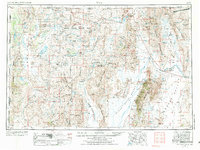
1954 Map of Vya
USGS Topo · Published 1984About this map
Sheldon National Antelope Refuge and the surrounding high desert plateaus define this expanse of the Great Basin during the mid-century. The landscape is marked by a complex network of internal drainage systems and isolated settlements such as Vya and Denio. Water is the critical factor for survival and ranching here, evidenced by the numerous developments like Bog Hot Springs and Reservoir and named water sources such as Miller and Lux Spring, which point to the region's history of large-scale cattle operations.
Find a feature on this map
129 named features on this map. Tap any name to fly to it.
Don’t see what you’re looking for? This feature index may not catch every label — zoom into the map to look around manually.
Map Details
Editions of this 1954 Vya Map
3 editions found

Other maps of this area

1882 · Paradise
USGS Topo · 1:250,000

1886 · Alturas
USGS Topo · 1:250,000

1886 · Honey Lake
USGS Topo · 1:250,000

1886 · Disaster
USGS Topo · 1:250,000

1886 · Granite Range
USGS Topo · 1:250,000

1889 · Long Valley
USGS Topo · 1:250,000

1891 · Honey Lake
USGS Topo · 1:250,000

1892 · Alturas
USGS Topo · 1:250,000

1893 · Paradise
USGS Topo · 1:250,000

1893 · Honey Lake
USGS Topo · 1:250,000