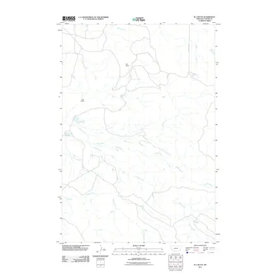
2011 Map of W L Butte
USGS Topo · Published 2011About this map
W L Butte stands as a prominent landmark in this part of Carter County, overlooking a network of ephemeral watercourses that define the local drainage patterns. The landscape is carved by the winding paths of Stump Creek, Timber Creek, and Keith Creek, along with their various tributaries including Middle Creek and Adams Creek. Human presence is marked by the tracing of Chalk Buttes Rd, which provides access through this section of the Montana high plains. The map reveals the intricate topographic detail of the region, from the low-lying York Draw to the more significant elevations. These features illustrate the ranching and natural character of the area, showing how the land is utilized and navigated in the early 21st century.
Find a feature on this map
9 named features on this map. Tap any name to fly to it.
Don’t see what you’re looking for? This feature index may not catch every label — zoom into the map to look around manually.
Map Details
Editions of this 2011 W L Butte Map
This is the sole edition of this map. No revisions or reprints were ever made.
Other maps of this area

1954 · Ekalaka
USGS Topo · 1:250,000

1956 · Ekalaka
USGS Topo · 1:250,000

1958 · Ekalaka
USGS Topo · 1:250,000

1965 · Ekalaka
USGS Topo · 1:250,000

1979 · W L Butte
USGS Topo · 1:24,000

1979 · Dutchman Creek
USGS Topo · 1:24,000

1979 · Chalk Buttes
USGS Topo · 1:24,000
1979 · Pocochichee Butte
USGS Topo · 1:24,000
1979 · Davis Creek West
USGS Topo · 1:24,000
1979 · Davis Creek East
USGS Topo · 1:24,000