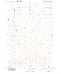
1979 Map of Pocochichee Butte
USGS Topo · Published 1979About this map
Moore School stands near the southern border of this landscape in Carter County, reflecting the sparse rural infrastructure of eastern Montana in the late 1970s. The terrain is defined by prominent topographical rises such as Pocochichee Butte, Saddle Butte, and the Honeycomb Hills, which overlook a network of intermittent drainages. A lone Cabin and a remote Landing Strip indicate the isolation of this ranching country, where the boundary between Powder River and Carter counties is marked along the western edge.
Find a feature on this map
16 named features on this map. Tap any name to fly to it.
Don’t see what you’re looking for? This feature index may not catch every label — zoom into the map to look around manually.
Map Details
Editions of this 1979 Pocochichee Butte Map
This is the sole edition of this map. No revisions or reprints were ever made.
Other maps of this area

1954 · Ekalaka
USGS Topo · 1:250,000

1956 · Ekalaka
USGS Topo · 1:250,000

1958 · Ekalaka
USGS Topo · 1:250,000

1965 · Ekalaka
USGS Topo · 1:250,000

1979 · W L Butte
USGS Topo · 1:24,000

1979 · Rattlesnake Ridge
USGS Topo · 1:24,000

1979 · McKenzie Creek
USGS Topo · 1:24,000
1979 · Davis Creek West
USGS Topo · 1:24,000
1979 · Davis Creek East
USGS Topo · 1:24,000

1980 · Broadus
USGS Topo · 1:100,000