1963 Map of Wa Keeney West
USGS Topo · Published 1964About this map
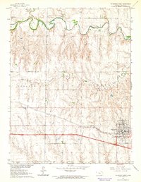
The Saline River winds through the northern portion of this High Plains landscape, joined by its North Fork and framed by seasonal drainages like Hay Hollow and Trego Creek. In the south, the city of WaKeeney serves as the regional anchor, centered on the Union Pacific railroad corridor. This mid-century survey illustrates a landscape defined by agricultural utility and early energy exploration, with scattered Oil Wells dotting the terrain northwest of the town center.
Find a feature on this map
15 named features on this map. Tap any name to fly to it.
Don’t see what you’re looking for? This feature index may not catch every label — zoom into the map to look around manually.
Map Details
Editions of this 1963 Wa Keeney West Map
This is the sole edition of this map. No revisions or reprints were ever made.
Other maps of this area

1893 · Ellis
USGS Topo · 1:125,000

1893 · Hill
USGS Topo · 1:125,000

1954 · Goodland
USGS Topo · 1:250,000

1955 · Great Bend
USGS Topo · 1:250,000

1955 · Scott City
USGS Topo · 1:250,000

1955 · Beloit
USGS Topo · 1:250,000

1956 · Goodland
USGS Topo · 1:250,000

1957 · Goodland
USGS Topo · 1:250,000

1957 · Great Bend
USGS Topo · 1:250,000

1958 · Great Bend
USGS Topo · 1:250,000