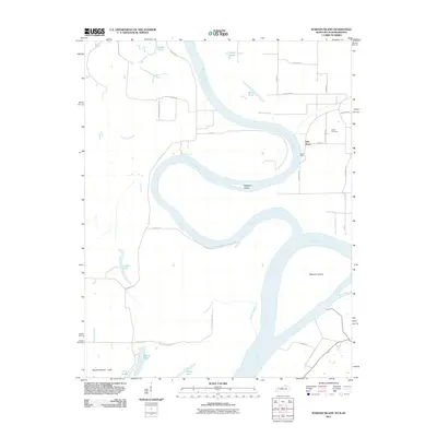
2011 Map of Wabash Island
USGS Topo · Published 2011About this map
The confluence of the Ohio River and the Wabash River dominates this tri-state border region, where the water has shaped both the land and its settlement history. The prominent Wabash Island sits at the heart of this riverine landscape, flanked by complex systems of backwaters like Running Slough, Mill Slough, and numerous bodies of water including Hulda Lake and Fehrer Lake. These features reveal a dynamic floodplain where agriculture and hydrology are inextricably linked, evidenced by features such as Bicketts Ditch Ln.
Find a feature on this map
39 named features on this map. Tap any name to fly to it.
Don’t see what you’re looking for? This feature index may not catch every label — zoom into the map to look around manually.
Map Details
Editions of this 2011 Wabash Island Map
This is the sole edition of this map. No revisions or reprints were ever made.
Other maps of this area

1905 · New Haven
USGS Topo · 1:62,500

1906 · New Haven
USGS Topo · 1:62,500

1907 · Morganfield
USGS Topo · 1:62,500

1916 · Shawneetown
USGS Topo · 1:62,500

1917 · Uniontown
USGS Topo · 1:62,500

1949 · Paducah
USGS Topo · 1:250,000

1949 · New Haven
USGS Topo · 1:62,500

1949 · Morganfield
USGS Topo · 1:24,000

1950 · Paducah
USGS Topo · 1:250,000
1951 · Morganfield
USGS Topo · 1:24,000