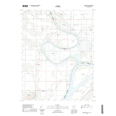
2019 Map of Wabash Island
USGS Topo · Published 2019About this map
The confluence of the Wabash River and the Ohio River defines this complex borderland where Illinois, Indiana, and Kentucky meet. The landscape is dominated by riverine features, notably the large Wabash Island and Mackeys Island, which sit amidst a network of active and relic watercourses. These wetlands, including Goose Pond, Fehrer Lake, and Berdick Slough, indicate a territory shaped by seasonal flooding and the shifting meanders of the river systems.
Find a feature on this map
56 named features on this map. Tap any name to fly to it.
Don’t see what you’re looking for? This feature index may not catch every label — zoom into the map to look around manually.
Map Details
Editions of this 2019 Wabash Island Map
This is the sole edition of this map. No revisions or reprints were ever made.
Other maps of this area

1905 · New Haven
USGS Topo · 1:62,500

1906 · New Haven
USGS Topo · 1:62,500

1907 · Morganfield
USGS Topo · 1:62,500

1916 · Shawneetown
USGS Topo · 1:62,500

1917 · Uniontown
USGS Topo · 1:62,500

1949 · Paducah
USGS Topo · 1:250,000

1949 · New Haven
USGS Topo · 1:62,500

1949 · Morganfield
USGS Topo · 1:24,000

1950 · Paducah
USGS Topo · 1:250,000
1951 · Morganfield
USGS Topo · 1:24,000