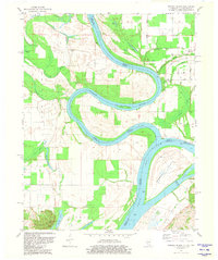
1981 Map of Wabash Island
USGS Topo · Published 1981About this map
The Wabash River meanders sharply through the bottomlands of the tri-state border region, creating a complex network of sloughs and overflow ponds before its confluence with the Ohio River. This 1981 edition captures the intricate hydrology of the area, featuring named water bodies such as Goose Pond Scatters, Berdick Slough, and Hulda Lake that reflect the shifting nature of these major waterways. The presence of Wabash Island dominates the southeastern quadrant, where the river serves as the primary boundary between Indiana and Kentucky.
Find a feature on this map
39 named features on this map. Tap any name to fly to it.
Don’t see what you’re looking for? This feature index may not catch every label — zoom into the map to look around manually.
Map Details
Editions of this 1981 Wabash Island Map
This is the sole edition of this map. No revisions or reprints were ever made.
Other maps of this area

1905 · New Haven
USGS Topo · 1:62,500

1906 · New Haven
USGS Topo · 1:62,500

1907 · Morganfield
USGS Topo · 1:62,500

1916 · Shawneetown
USGS Topo · 1:62,500

1917 · Uniontown
USGS Topo · 1:62,500

1949 · Paducah
USGS Topo · 1:250,000

1949 · New Haven
USGS Topo · 1:62,500

1949 · Morganfield
USGS Topo · 1:24,000

1950 · Paducah
USGS Topo · 1:250,000
1951 · Morganfield
USGS Topo · 1:24,000