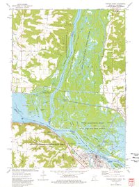
1974 Map of Wabasha North
USGS Topo · Published 1976About this map
The Chippewa River flows into the Mississippi River delta, creating a complex network of sloughs and islands along the border of Minnesota and Wisconsin. In this mid-1970s landscape, the town of Wabasha and the riverside settlement of Reads Landing occupy the Minnesota shore, while Nelson and Trevino sit on the Wisconsin side. The area is defined by massive conservation tracts, including the Tiffany State Public Hunting Grounds and the Upper Mississippi River Wild Life and Fish Refuge, which preserve the labyrinthine waterways of Battle Slough, Shively Slough, and Dark Slough.
Find a feature on this map
62 named features on this map. Tap any name to fly to it.
Don’t see what you’re looking for? This feature index may not catch every label — zoom into the map to look around manually.
Map Details
Editions of this 1974 Wabasha North Map
2 editions found
Other maps of this area

1929 · Durand
USGS Topo · 1:62,500

1932 · Wabasha
USGS Topo · 1:62,500

1932 · Durand
USGS Topo · 1:62,500

1932 · Alma
USGS Topo · 1:62,500

1935 · Arkansaw
USGS Topo · 1:48,000

1941 · Arkansaw
USGS Topo · 1:62,500

1942 · Arkansaw
USGS Topo · 1:62,500

1950 · Alma
USGS Topo · 1:62,500

1951 · Wabasha
USGS Topo · 1:62,500

1953 · Saint Paul
USGS Topo · 1:250,000