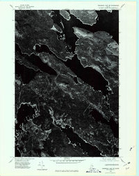
1975 Map of Wabassus Lake NW
USGS Topo · Published 1980About this map
West Grand Lake dominates this aerial perspective of the Maine wilderness, its intricate shoreline and deep-water coves seen here in late autumn. The 1975 photoimagery reveals a landscape of dense forest and glacial hydrology, where the high ground of Dark Cove Mountain rises above the surrounding timberland. This orthophotoquad provides an unvarnished look at the region’s topography before digital mapping, capturing the literal texture of the woods and the precise boundaries of the lake's many inlets. It is a document of the Maine North Woods during a period of industrial forestry, showing the network of logging tracks and clearings that cut through the canopy between the water's edge and the mountain slopes.
Find a feature on this map
2 named features on this map. Tap any name to fly to it.
Don’t see what you’re looking for? This feature index may not catch every label — zoom into the map to look around manually.
Map Details
Editions of this 1975 Wabassus Lake NW Map
This is the sole edition of this map. No revisions or reprints were ever made.
Other maps of this area

1931 · Springfield
USGS Topo · 1:48,000

1932 · Nicatous Lake
USGS Topo · 1:48,000

1934 · Nicatous Lake
USGS Topo · 1:62,500

1934 · Springfield
USGS Topo · 1:62,500

1941 · Scraggly Lake
USGS Topo · 1:62,500

1941 · Wabassus Lake
USGS Topo · 1:62,500

1943 · Wabassus Lake
USGS Topo · 1:62,500

1944 · Scraggly Lake
USGS Topo · 1:62,500

1953 · Wabassus Lake
USGS Topo · 1:62,500

1954 · Millinocket
USGS Topo · 1:250,000