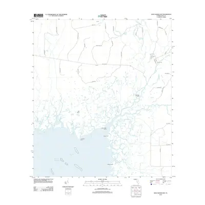
2012 Map of Waccasassa Bay
USGS Topo · Published 2012About this map
The Waccasassa River and Wekiva River converge in this coastal section of Levy County, forming a complex network of tidewater creeks and sloughs that empty into the Gulf of Mexico. The landscape is dominated by marshy islands and points, including Staffords Island, Lone Cedar Island, and Salt Island. Inland, the map reveals a pattern of rural camps and resource-extraction roads such as Camp D, Camp E, and Williams Camp, connected by thoroughfares like Main Line Rd and Buck Island Rd. This intricate hydrography, featuring named channels like Chicken Slough and Watch Chain Slough, illustrates the untouched nature of the Big Bend coastline as it remained into the early 21st century. The map provides a detailed look at the interface between the wooded hammocks and the open Waccasassa Bay.
Find a feature on this map
65 named features on this map. Tap any name to fly to it.
Don’t see what you’re looking for? This feature index may not catch every label — zoom into the map to look around manually.
Map Details
Editions of this 2012 Waccasassa Bay Map
This is the sole edition of this map. No revisions or reprints were ever made.
Other maps of this area

1954 · Otter Creek
USGS Topo · 1:24,000

1954 · Chiefland SW
USGS Topo · 1:24,000

1954 · Bronson SW
USGS Topo · 1:24,000

1954 · Gainesville
USGS Topo · 1:250,000

1955 · Lebanon Station
USGS Topo · 1:24,000

1955 · Withlacoochee Bay
USGS Topo · 1:24,000

1955 · Waccasassa Bay
USGS Topo · 1:24,000

1955 · Yankeetown
USGS Topo · 1:24,000

1955 · Sumner
USGS Topo · 1:24,000

1958 · Gainesville
USGS Topo · 1:250,000